An ever-increasing number of fire departments around the country are abandoning their old mobile data solutions in favor of newer cloud-based response software technologies that focus specifically on the unique needs of firefighters.
“Much of the older mobile data solutions were designed for police and just weren’t giving firefighters what they needed,” explained Richard Ferguson, Product Specialist with StreetWise CADlink, one company that has been developing a new breed of mobile response software. “There’s nothing sadder than looking in a fire truck and seeing an expensive laptop computer with the lid closed and a map book, pre-plan binder or a coffee cup sitting on top of it.”
Initially, the company assembled a group of fire officers of various ranks from around the country, big departments and small, asking what they would most like to see in their mobile data solution. The results indicated that what fire officers wanted most was not even remotely similar to what they had.
“They asked for simplicity, speed, affordability and, above all, situational awareness,” said Ferguson. The feedback indicated that most departments either could not afford a networked mobile data solution or that what was available from their dispatch center basically replicated the dispatcher’s screen. “It wasn’t what they needed,” he added.
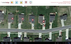
Ferguson says the new response software was specifically built with the feature set requested by the fire officers’ research group to include various tactical map views, navigation and routing, water supplies, live unit locations and the ability to coordinate incident information and waypoints to all responders instantly.
According to the Pensacola, FL, Fire Department, a current user, the new approach is working.
“I don’t need my firefighters spending their time on the way to a call just deciphering the dispatcher’s screen and second-guessing them. I need the firefighters to be reviewing pre-plans, finding their water supply, checking the surroundings and coordinating incoming resources,” said Pensacola Fire Captain Jarrod Gruber.
Another source of concern voiced by the research group was interoperability. Departments located right next to each other, responding together on a daily basis, could not actively share information on their mobile devices.
“We recognized early on that we would need to build this new system as a universal mobile data system operating off of centralized international servers, so that we could completely remove the artificial silos created by individual communication centers and their proprietary mobile software,” said Olivia Binstead, Customer Support Manager for StreetWise CADlink. “Using cloud servers, departments in California can share data in real time with departments in Connecticut. The old walls are knocked down.”
“Our research group also demanded more mobility. One of their big complaints was that their mobile data solutions were running on laptops that required external GPS and broadband devices,” Ferguson said. “They simply weren’t very mobile. Several departments told us they only removed the laptop from the truck if it broke.” As a result, the new system was designed for the burgeoning market of tablet computers.
“We grab the tablet right off the mount and carry it with us. We can continue to monitor the incident and our resources even when we’re not in the truck,” said Gruber. “In one case, we coordinated search teams in a large wooded area, live, right over the tablets.”
Captain Peter Busa of the Fort Hunter, NY, Fire Department told a similar story. His district covers portions of the 3,200-acre Pitch Pine Scrub Oak barrens.
“This response software proved to be an incredibly valuable tool while fighting this season’s brushfires,” Busa said. “Utilizing the tactical map and all the features available, we were able to quickly determine which trails into the Pine Bush would give us the quickest and most effective approach to the fire. The waypoint markers on the tactical map proved to be extremely useful as we documented and shared apparatus locations, fire perimeter markers, and other information involved in the fire. We have fought fires in the Pine Bush for many years, but this year was the first time we had technology on our side, and it made a huge difference.”
With speed being critical, it was apparent the system would need to be built on live networking.
“We knew up front that we couldn’t depend on Push Notification Services that are used on smartphones to send messages such as Facebook updates and Groupon deals,” said Ferguson. “The data had to move live, not 20 minutes into an incident. If it wasn’t completely reliable from a speed perspective, firefighters would never come to depend on it. Because of that, we simply can’t hand the data off to a third party in hopes that they’ll deliver it for us.”
The approach worked. The system uses confirmed and encrypted device-to-server communication for latency of just a few seconds on every action.
“Our tablets frequently activate before the station alerting system goes off,” said Pensacola Battalion Chief Brock Jester. “When we place an incident waypoint on the tactical map, everyone sees it in seconds.”
The system was also designed with a huge focus on pre-incident planning.
“There is a big resurgence of interest now in pre-plans,” said Binstead. “Departments know pre-plans can improve firefighter safety and situational awareness, not to mention the ISO credit available, and they’re extremely interested in fully consolidating their pre-plan program into their response software.”
The new system was designed with a full pre-planning suite, including both the ability to quickly create a pre-plan in the field and to display it intelligently on the device. By storing the data in the cloud, pre-plans are instantly synchronized and can be shared with neighboring departments.
“Rather than pulling out a binder and going through all these papers to try to find a business, it’s right there on the tablet. We can pull it up and we can see the hazards, we can see the fire department connection location, any special issues with the building, sizes, what the roof looks like, all from the tablet,” said Jester.
Chief Jason Mihalek of the Richfield, OH, Fire Department said, “It provides better protection for the firefighters because they have more information at their fingertips that could prevent them from maybe going into an area in the building that they shouldn’t be. It takes a lot of the extra stressors off of that first-line company officer who’s on an engine making a lot of rapid decisions.”
“Because the response software is specifically designed for the needs of firefighters, it’s rapidly gaining acceptance,” Ferguson said.
“Once it was in the trucks, the buy-in was immediate. It was seamless,” said Jester. “Even the saltiest firefighters we have, the ones that would say ‘you can’t make me do this,’ are begging for it now. I don’t know if they could live without it.”
PHIL KOUWE, EFO, spent over 22 years in full-time fire and EMS delivery, with 14 years as a chief officer. He also served as a division president of the International Association of Fire Chiefs (IAFC) and a member of the Indiana Fire Prevention and Building Safety Commission, and received the Governor’s Award for Meritorious Service for the State of Indiana for his statewide work in fire prevention, code development, public education and promotion of residential sprinklers. Kouwe is a graduate of Pike’s Peak Community College and the National Fire Academy’s Executive Fire Officer (EFO) Program. He is now president/CEO of Hangar 14 Solutions, LLC, a fire service technology company.
Connect with Phil
Facebook: StreetWiseCADlink
Twitter: stwisecadlink
LinkedIn: philkouwe
Email: [email protected]
Website: hangar14solutions.com


