GPS Devices Help New York Firefighters Pinpoint Calls
GATES, N.Y.-- In March, Gates Fire Department crews responded to a bolt of lightning striking the chimney of a two-story single-family home on Pinewood Knoll in Chili.
Four months later, they dealt with a possible hazardous chemical spill scare at one of the town's largest businesses.
A year ago, firefighters on their way to those scenes could only prepare themselves with paper maps.
But a $36,000 State Archives grant changed that.
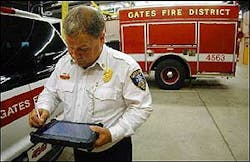
The funds helped the department purchase four Global Positioning System devices in February, making it the only suburban fire department in Monroe County that uses the sophisticated equipment.
The devices allowed responding firefighters to punch in the address of each incident, pull up the schematics of each building, locate water mains and determine the best way to get to the scene and start controlling the situation faster than ever before.
"In fire service, lost time during the decision-making process leads to the potential for loss of life, additional property damage and the escalation of an incident," said Jim Harrington, the Gates fire chief.
Nationwide, fire departments use cell phones with GPS to track the speed of each truck and the number of crew members on board. Most other departments are on the outside of the developing trend, mainly for financial reasons.
William Pessemier, who works for a think tank set up by the International Association of Fire Chiefs, based in Fairfax, Va., said that without GPS, there is no accurate way to track what's happening on the ground.
"All you have is verbal communication over radios instead of being able to track all your units by watching it on a screen. You don't have tremendous control of all your resources."
How GPS works
Gates purchased four GPS devices, at least one for every station. They resemble mini-laptops that are fastened to the dashboard of firetrucks. The grant covered the entire cost. Firefighters punch in the exact address of a location and receive the latest available 360-degree view of the building and neighboring facilities.
Gates uses the technology to display aerial photography, Geographic Information Systems and Material Safety Data Sheets information, which indicates the chemical makeup of hazardous materials in any building. The system also identifies water hydrants and mains.
When new streets are built, Monroe County notifies Gates so the GPS can be updated. While the firetruck's driver is focused on getting to the scene, the person riding shotgun verbally relays the GPS information to the crew while in transit.
"This is going to take firefighting to a new level, where instead of trying to remember what a house or building looks like, you're going to get up-to-date aerial views on every side," said Joe Mott, the department's communication and technology coordinator. "A lot of people are scared of technology, but this is a system that is going to be here for some time. Every department should have GPS capabilities."
On July 25, Gates Fire Department crews dealt with a hazardous material spill at Rochester Technology Park on Manitou Road. Several chemicals had come together in a drum, possibly causing a dangerous reaction.
Using the GPS devices, the firefighters were able to get expert chemical advice about the compounds and elements that made up the chemicals to gauge whether firefighters would be in danger entering the building. They learned they weren't.
In addition, the equipment allowed crew leaders to scan the entire complex in a couple of seconds through the computer instead of sending a small reconnaissance team to determine the best mode of entry.
"I call this working smart," said Harrington. "It's a chance to use a powerful tool and the best methods available to achieve our goal."
Since 2001, the Gates department has averaged 1,706 service calls a year, excluding emergency medical service. Gates serves close to 32,000 residents with about 87 volunteer and 20 paid firefighters.
Other departments
While the Barnard Fire Department in Greece responds to more than 3,000 calls a year, there's no push there to have GPS capacity.
"It's expensive and it's not on the top of the priority list," said James Gallagher, assistant chief of the department, which serves 25,000 citizens in a 4-square-mile area.
Greece department officials hope to install a computer with Pictometry in one of its trucks next year that makes it possible to view the exterior layouts of buildings. But the data, which is several levels below GPS and provided by the town of Greece, is three years old.
Vin Nolan, Brighton's fire chief, supports the idea of having GPS devices on his firetrucks, but he also said the cost would likely make that impossible.
He's not the only small-town chief facing that problem.
"It's mostly the big cities that can combine resources with its fire, police and public works department to pay for the same GPS system," said Pessemier, an executive fellow for the International Fire Service Research Center and Policy Institute. "It's difficult for volunteer fire departments to pay for GPS, but the good news is that the technology is getting less expensive because of competition from more companies offering the equipment.
"Plus, sometimes departments have a difficult time envisioning the creative ways they can use new technology."
While the Hartford, Conn., Fire Department has been heralded on the East Coast for effectively using new technology, its deputy chief acknowledged that his department is an exception.
"Fire departments have traditionally followed an old-school philosophy of 'let's do it the way it has always been done,'" said Eugene Cieri. "We don't often change, and that doesn't make any sense because it saves you so much time over trying to radio everyone to find out where they are."
Larger fire departments, however, are making advances.
This year, departments in New York City and Chicago employed GPS receivers that with the help of sensors provide accurate department vehicle locations, even in tunnels and underground parking garages.
Using technology
Brett Lim, director of marketing for Radio Satellite Integrators Inc., said fire departments began requesting GPS units about nine years ago, but the numbers have grown significantly since the Sept. 11, 2001, terrorist attacks.
Radio Satellite Integrators Inc. implements GPS technology for a variety of nationwide customers, including the U.S. Postal Service and U.S. Army.
"The technology has been there for a long time, but it's slowly becoming understood by the general public," he said.
Matt Cunningham, who is a paid Rochester firefighter who also volunteers in Gates as a firefighter, embraces anything that will help him and his fellow crew members perform their jobs better.
"We still, of course, need men to put the nozzle in and fill the water since there is no electronic way to fight a fire. But it's great to have the resources before you get to a scene," said Cunningham. "It has saved us time in many instances."
Republished with permission of The Rochester Democrat and Chronicle.