GeoLynx Server

Oct. 20, 2010

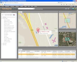
GeoLynx Server is a dispatch Web GIS application that enables tactical GIS dispatch within a public safety network. GeoLynx Server will seamlessly connect PSAPs, responding agencies, and mobile responders, increasing their ability to gather and share information, and respond to and track emergencies. It provides a common operating picture (COP) of your agency's geographic coverage area and emergency response activities for all web users to see and interact with. This helps to create a shared situational awareness for all users of the application.

Request More Information

By clicking above, I acknowledge and agree to Endeavor Business Media’s Terms of Service and to Endeavor Business Media's use of my contact information to communicate with me about offerings by Endeavor, its brands, affiliates and/or third-party partners, consistent with Endeavor's Privacy Policy. In addition, I understand that my personal information will be shared with any sponsor(s) of the resource, so they can contact me directly about their products or services. Please refer to the privacy policies of such sponsor(s) for more details on how your information will be used by them. You may unsubscribe at any time.