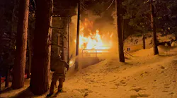
On June 24, 2021, the Champlain Towers South condominium in Surfside, FL, collapsed without warning and became the third-deadliest engineering failure in U.S. history. The incident resulted in 98 deaths and 11 injuries. The collapse was over in 11 seconds. More than 80 fire rescue units responded along with an equal amount of law enforcement units.
The incident came into Miami-Dade Fire Rescue (MDFR) as an alarm activation that was caused by a sprinkler water flow alarm at approximately 1:22 a.m. On arrival, the department was confronted with a massive building collapse, an overwhelming debris pile, four survivors who were on or near the surface and people who were trapped on the remaining section of the condominium. There was concern about the structural integrity of the remaining section of the towers.
The nature of the collapse was unique, because it largely was a pancake collapse, which offered very little hope for survivors. Although several responders compared their experience with that of 9/11, they explained that Surfside was very different, because most of those who were caught in the collapse literally were buried alive where they were, and many of their bodies were intact.
As with any collapse of this magnitude, there was concern regarding the cause. If believed to involve terrorism, criminal intent or gas leak, responders had to determine whether there was a chance of a secondary explosion and/or potential for more collapse.
As MDFR Battalion Chief Brandon Webb explained on arrival, size-up of a massive collapse such as this goes through a process of providing care to those who self-rescued, quickly rescuing those who were lightly trapped, rescuing those who were surfaced trapped, identifying victims, exploring void spaces and, lastly, the laborious delayering of the debris pile.
The remaining stairwell of the south tower was blocked and had separated six inches from the adjacent wall. This required MDFR to initiate a significant number of rescues by tower platforms. Webb had engineers methodically assess the integrity of the structure by looking at the columns floor by floor before allowing firefighters to go too far into the structure and onto each floor.
The initial 48 hours utilized Florida Task Force-1 and Florida Task Force-2. As the incident developed, the remaining six state teams responded. Ultimately, five additional federal task forces were deployed.
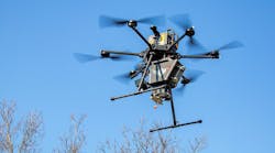
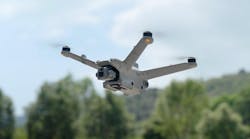
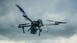
Drones: all-important
USAR teams are well-equipped with technologies to use at major collapses, such as listening devices, special extended cameras, thermal imaging cameras and hazmat detection equipment. However, because of the pancake collapse, most of those technologies were of little value, because there were no significant void spaces where people might have been trapped and possibly survived. One technology that demonstrated its value was the drone. MDFR Capt. Derrick Foster says their value “cannot be overstated.”
Drones provided lighting above the debris pile before ground lighting was established.
Throughout the incident, drones were flown by each of USAR teams and a team from Florida State University (FSU). Drones provided: overwatch of the debris pile and surrounding area; interior flights to access difficult areas and/or areas that were dangerous from a potential collapse standpoint; and mapping of the incident scene and surrounding area, for engineering evaluation of structural integrity, for forensic investigation and for volumetric assessment of the debris pile.
Scott Dean of City of Miami Fire Rescue says that when drones were introduced to the fire service, he wasn’t sold. However, since that time and particularly with hurricane and Surfside responses, he affirms that drones are an effective tool, and he now oversees MDFR’s unmanned aircraft systems (UAS) team.
Flight coordination
When drones fly in the national airspace (NAS), it’s critical to take measures to control and coordinate flights in and around the affected area. Early on, piloted news helicopters flew over the incident scene. Webb says that the noise from the rotor wash could make it difficult for rescuers to communicate. Helicopters that flew at a low altitude also could generate enough vibration to cause the remaining unstable section of the building to collapse. Quickly, a temporary flight restriction was requested from the Federal Aviation Administration (FAA). This helped to maintain the safety of the responders and of those who were being rescued as well as to allow the public-safety drones to fly safely and without interference or interruption.
The first coordination of drones on scene in Surfside was conducted by simple group text messages. As more agencies and more remote pilots became involved, it was necessary to change to something that made managing group messages easier. They transitioned to the WhatsApp mobile application. It allows the development of group text to easily share information, which can be sent to mobile phones and other mobile devices—in this case, to coordinate the assignment of designated areas of flight by the various teams. Simultaneously, all teams knew the mission, assignment areas and flight times, as did the command staff, police and the FAA.
FSU collaboration
The FSU team arrived on June 25 and began mapping operations. David Merrick, who is the director of FSU’s Emergency Management and Homeland Security Program, tells Firehouse Magazine that flights began at two-hour intervals for two missions in Pix4D, 2D one grid and 3D overlap grid, and processing took place four times per day then three times per day. This included flights that spanned more than 2.5 acres for three weeks.
FSU also worked with Esri, the FEMA GIS Team, the Miami-Dade County GIS team and the National Alliance for Public Safety GIS (NAPSG) Foundation to integrate drone data into GIS. Ultimately, FSU’s team was assigned to the planning section to provide regular updated situational awareness mapping of the entire area that was affected.
The National Institute of Standards and Technology’s National Construction Safety Team (NCST) used drones to gather overview and detailed imagery of the site and of specific elements of the building. The imagery was used for close documentation of evidence, evidence identification and collection, and general situational awareness. The NCST also coordinated with responders who used drones to generate daily two-dimensional orthorectified mosaic images and three-dimensional digital elevation models.
Vendors deliver
Drone solution providers and drone manufacturers provided support during the incident.
Locally, Drone Nerds provided cameras for the MDFR drones and helped with the installation and support of the devices.
BRINC Drones CEO Blake Resnick says his company’s Lemur S drone provided interior flying and established a repeater-like network that allowed the drone to fly farther into the parking collapse area to look for survivors and to provide information to engineers on the structural integrity.
DroneSense provided a means of operating all drones under one mission. This greatly enhanced the capability of various groups to see the information relative to their respective areas of responsibility.
DroneSense identified needs from this incident and, as a result, implemented two new features: Magic Video Link makes it easier to share a video streaming link, and a notification feature informs of a drone launch to all of those who must know as part of a mission.
Fotokite provided a tethered drone, which provided a constant flight and overwatch. This allowed an easy switch to thermal imaging from visual optics.
Esri says it was requested for disaster-recovery-plan assistance for help with data collection and imagery/3D processing.