
The take on drones in the fire service is transitioning quickly from “nice to have” to “need to have.” Every day, drones’ capability to provide situational awareness that directly enhances responder safety and improves operational effectiveness is improving.
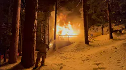
The combination of critical information from dangerous situations and keeping responders out of harm’s way, which drones provide, emerges in particular in regard to responses that involve hazmat, wildfires, SWAT operations and active-shooter situations and in the search for lost persons in extremely dangerous areas.
What are the keys to the continued development/improvement of drones’ capabilities? They are numerous: better sense-and-avoid technology, an expanded array of remote sensors, increased flight time, side-by-side visual and thermal cameras, the capability to grab and to release items, lighting devices, speakers, augmented reality, artificial intelligence (AI) and facial recognition.
What you see
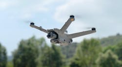
A dual set of side-by-side visual and thermal cameras, which allows users to capture heat signatures and to measure temperatures (which is extremely helpful to emergency response) is an extremely appealing facet of the Mavic series drones, which are manufactured by DJI. Add in the fact that the Mavic also includes an ultracompact/foldable design, ease of use, affordability, and an attachable spotlight and speaker, and it isn’t surprising that the DRONERESPONDERS program found that 73 percent of public-safety UAS operators are flying a Mavic series drone.
A new feature of the Mavic series is HeatTrack; it automatically tracks the hottest object in view. That could be useful in search and rescue, because the drone can hone in on a missing person.
To address concerns regarding the security of data, the Mavic 2 Enterprise Dual provides heightened data security. When activated, the Local Data Mode feature in the DJI Pilot App prevents the sending or receiving of any data over the internet.
The same model’s AirSense technology alerts drone pilots of ADS-B signals from nearby airplanes and helicopters. This is a very important feature. Most major incident/disaster responses involve both manned and unmanned aircraft.
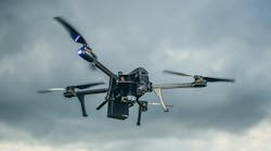
Creating sharper images and providing the capability to slow down footage allows first responders to latch on to extra detail. This is important when they are trying to gain perspective on an incident. Drone manufacturer Autel says its public-safety model, the EVO, is the only portable folding drone that captures 4K video at 60 feet per second.
Other impressive facets of the EVO: It doesn’t include flight restrictions, which ensures that it won’t be restricted in a critical operation; it doesn’t require a firmware update before it’s put into use; and it can go from its case to in the air in 30 seconds.
The EVO’s capability to connect wirelessly to Autel’s Live Deck facilitates, essentially, operation via a second remote and provides an HDMI, Ethernet and mouse/USB port, so the video feed can be output.
Autel apparently isn’t standing pat when it comes to the images that its drones can provide. One of the gimbals on a new drone will include an option of a dual-sensor, 8K camera and a 640 x 512 FLIR sensor. The company says this will provide the most flexible camera package on any folding and portable drone with much better sense-and-avoid technology.
An impressive, new sense-and-avoid technology is behind the excitement of the Skydio 2’s launch. It’s touted as the only drone that doesn’t require remote pilot skills. Six 4K, 200-degree color navigation cameras utilize 45 megapixels of visual sensing to see in every direction. Many who have flown the drone say it’s impossible to crash even when trying to do so.
To process all of the information that’s collected by the six cameras, the drone uses the Nvidia Tegra TX2, which is reportedly the fastest, most power-efficient embedded, AI computing device.
The drone has been found to offer unsurpassed safe flight in areas that are riddled with obstacles. For example, it maneuvers very well in confined spaces and can fly under a tree canopy with ease. Such capability is critical in time-sensitive, confined tactical situations; the remote pilot can focus on flying the mission without concern of crashing the drone. Many police officers who flew the Skydio 2 call it a game-changer.
Unfortunately, the drone can’t fly at night, and it lacks a FLIR thermal-image capability. Skydio reports that it’s continuing development to address these issues.
No ‘pilot’ required
Pierce Manufacturing and drone manufacturer Fotokite partnered to create the Pierce Situational Awareness System by Fotokite. It incorporates a tethered drone into the design of new fire apparatus, or the system can be retrofitted into existing apparatus. Under the most recent Reauthorization Bill from the Federal Aviation Administration (FAA), a person who flies the drone doesn’t require FAA remote-fly certification.
The system provides side-by-side visual and thermal-image cameras and can provide continuous situational awareness through live stream. Training can be accomplished in one day.
In a beta-program rollout, the system was operated in more than 1,500 missions by fire departments across the country, including live fire responses, search-and-rescue missions and training exercises. Shipments of the system began in December 2019.
Incorporating the Genesis PULSE computer-aided dispatch enhancement, the FIRST iZ (pronounced “eyes”) drone system is designed to respond to calls autonomously. Expected to be beta-tested in 2020, the system will be included on a unique quadcopter that will clock at faster than 60 mph.
Remarkable drone work
The Chula Vista, CA, Police Department (under the FAA San Diego Integration Pilot Program) has done remarkable work through their Drone as First Responder (DFR) Program. The department’s UAS (Unmanned Aerial System) Program’s mission is to provide airborne support to police operations in a safe, responsible and transparent manner to preserve the peace, reduce response times and increase the quality of life in Chula Vista. Achieving one of the first Beyond Visual Line of Sight (BVLOS) waivers, the department can fly quickly to emergency incidents. As of Dec. 19, 2019, the DFR flew 1,192 missions. It assisted in 164 arrests and made the need for the deployment of a ground unit unnecessary 244 times. The drone program was first on scene 541 times, and its average on scene response time was 182 seconds.
The DFR also has helped to increase priority of response as necessary and provide invaluable information to deescalate situations.
More recently, the department has been exploring the use of the Skydio 2 for tactical operations. Through the use of the Skydio advanced sense-and-avoid technology, the department was granted Close Proximity/Low Altitude (CPLA) BVLOS operations under their existing certification of wave or authorization (COA) to allow operations around and behind buildings for dangerous situations and to keep police officers out of harm’s way. CPLA BVLOS allows for tactical operations less than 100 feet above ground level (AGL) and out 750 feet laterally.
The combined UAS team of the York County, VA, Fire & Life Safety and the York-Poquoson Sheriff’s Office was granted an FAA CPLA BVLOS waiver to operate less than 150 feet AGL and 750 feet laterally. The waiver resulted from extensive research and documentation on the two department’s jurisdiction, operations and safety cases. It will allow responders to operate BVLOS during tactical operations around and behind buildings that present a high degree of danger to responders.
Harmonization
Clearly, drones are making a huge difference for the fire service and public safety. For public-safety UAS programs to succeed, there needs to be a means to communications, coordination and collaboration.
DRONERESPONDERS (droneresponders.org) was organized to do just that. Membership is free and provides access to one of the largest online public-safety UAS repositories (SOPs, policy manuals, training programs, etc.) in the world. The organization will host its Major Cities Working Group UAS Meeting and its Global Public Safety UAS Summit at AUVSI’s XPonential event in Boston in May 2020.


 and Teledyne Director Greg Nagler (c.) present the SIRAS to Joey Dockins, who accepted the award on behalf of winner Jerod Davenport.")