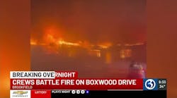
A firefighter radios that he is down, but is too overcome to say where. A hot spot suddenly flares up and explodes, needing more water and manpower. A father frantically tells firefighters he couldn’t reach the back bedroom to get his children out of the house in time.
In each of these instances, time, information and, perhaps most importantly, the whereabouts of each firefighter helping to quench the flames and rescue people are of the utmost importance. The more that those on the scene can discern about a situation, the better the chance they have of reaching people in need or fighting the fire in the most efficient manner possible, especially in the quickly changing environment of a fire.
Soon, indoor-location information systems will help firefighters locate a downed colleague or find a back bedroom or staircase that is obscured by smoke. Systems designed to help by providing information on the location of firefighters have been in the works for years. The good news is that commercial indoor-location systems, which will eventually become the systems used by firefighters, are being deployed today. It is the experiences of first adopters such as campus and VIP security providers, law enforcement agencies and military training facilities that currently are helping system developers learn exactly what they need to do to tailor their systems to meet the stringent requirements of firefighting environments.
How Location Works
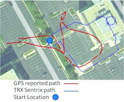
Most people are familiar with GPS technology and its ability to track things as they move outdoors using satellites. As long as they are in view of the satellites and equipped with up-to-date and complete software, GPS devices are able to provide end users with a pretty reliable solution. However, most are far from perfect, so people sometimes must use what they can see or know about an area to make corrections.
Indoors, things also can be tracked using radio waves coming from tags affixed to infrastructure or inventory. This technology also performs well, but retrofitting every existing structure is unrealistic and, in any event, fixed infrastructure or tags are not likely to remain in place or fully functional in a burning building. More recently, Wi-Fi signals have been used by cellular to devices to enhance tracking results. However, accuracy using existing hot spots is at best 10 meters and is often up to 100 meters (or non-existent, where most locations simply don’t have hot spots installed).
Where Are You Going?
With a mind to increase safety and efficiency of firefighters as their ultimate goal, approximately five years ago, companies such as TRX Systems Inc. began researching the ability to track people as they moved through indoor, underground or unfamiliar GPS-denied locations. Their aim was to deliver precise, infrastructure-free, indoor-location information without using any of the surrounding environment or tags affixed to inside infrastructure.
TRX developed a system featuring unique sensor-fusion capabilities that integrate a diverse array of sensor and mapping information (when available or able to be inferred from other sensor data) to deliver ever increasingly accurate, infrastructure-free location of people moving around indoors, underground or in any other GPS-denied environment. A person being tracked wears a small tracking unit that communicates through cellular data or radio systems to a command center.
The command center uses the information it receives from the tracking devices to compute and then display the location of all personnel wearing the devices, which also can provide their wearers with voice communications to the command center. The information can be used to track the personnel on existing maps. Where no maps exist, data coming from the sensors can be used to create maps as people wearing the sensors move around the environment. The sensors also can tell people at the command center whether a person is crawling, on his or her back or climbing stairs, etc.
The TRX system and others now are available for a wide variety of personnel tracking applications. They currently meet requirements for security, urban training, corrections and personnel operating in indoor environments. For these applications, without any additional pre-installed infrastructure, the systems can accurately locate the floor and quadrant of a building in which a person is located. Additionally, early adopters in the fire community are beginning to deploy these tools in training environments and burn buildings to partner with companies as they complete development.
These early commercial deployments will keep the infrastructure-free indoor-location technology on the fast track for use by the end users for whom it was first imagined – firefighters. And because real-time awareness and increased “visibility” are so critical to what they do, firefighting agencies worldwide are waiting patiently, yet expectantly, for the technology to mature to a point where it meets the stringent requirements of a firefighting environment. The requirements are set high because the stakes are high – these location-tracking systems will be used in the most demanding firefighting environments.
In addition to what they learn from commercial deployments, the industry is being supported by the Department of Homeland Security (DHS) to perform research and development to increase the accuracy of tracking systems to meet the high accuracies required by the firefighting environment. TRX is a member of one of the teams (along with Boeing/Argon ST and Thales) contributing to and supported by the first phase of the DHS Geospatial Location Accountability and Navigation System for Emergency Responders (GLANSER), which will deliver even more precision in support of first responder location and tracking.
Globe Manufacturing Co. has also teamed with TRX and Zephyr Technologies in a project called WASP, for Wearable Advanced Sensor Platform. WASP will integrate body-worn electronics into a base layer shirt and turnout gear to combine physiological monitoring and location and tracking technologies into one common system that may be easily deployed operationally for the fire service.
Cost Effective
It’s no secret that municipalities and government agencies are watching every penny that they spend, so cost and value are important factors in the eventual uptake of these systems. They must be available to a wide array of customers to keep the prices down and must enhance the existing processes and procedures of the firefighters while managing within their increasingly constrained yearly budgets.
Indoor location relies on sensor technologies, including accelerometers, gyroscopes and altimeters, along with radio signals and map information. Many of these are the very sensors that are now being embedded in cellular and gaming devices. Driven by these large commercial markets, the performance of the underlying sensors is maturing rapidly and the costs are expected to decrease. Industry investments in ranging sensors are driving innovations that deliver accuracy even indoors, where obstacles can often interfere with signals to drive errors. In addition, accurate 3D building information models are becoming more and more widespread. Navigation fusion algorithms can use these sensor and mapping enhancements to deliver improved tracking accuracy. All of these market forces, along with the government and industry investments being made, are helping indoor location technology to meet GLANSER requirements at what will be increasingly competitive price points.
Just as cell phones have turned into devices that let us do much more than talk to one another, infrastructure-free indoor-location systems will evolve into tools that enhance and change the way firefighters accomplish their tasks. Firefighters will be able to save time at the scene and make better decisions more quickly. But most importantly, these systems will help to save lives of firefighters and people they are trying to rescue.
