Wildfire Detection in the 21st Century
A key component in successfully preventing widespread destruction from wildfires is early detection. In years past, fire agencies have constructed fire lookout towers staffed 24 hours a day by spotters who were relied upon to alert firefighters about new blazes in wildland areas. At the time that the first such towers were erected in the U.S. in the early 1900s, communications were accomplished via carrier pigeons and heliographs (mirrors used to flash Morse code messages), and an Osborne Fire Finder was used to plot the locations of fires.
With the advent of cell towers, satellite GPS systems, and computers, the art and science of fire detection has moved into the 21st century. This is the first of several articles that will survey the field of modern-day wildfire detection and provide some insight on how current technology enables fire agencies to better detect wildland fires.
Envirovision Solutions
Based in South Africa, Envirovision Solutions (EVS) fields a wildfire detection vision system called ForestWatch, which combines camera systems with computer software to determine the onset of a wildfire, map the fire line, and provide fire imagery with associated GIS information to help fire agencies deal with wildland blazes. The organization has deployed their wildfire camera systems to many remote areas in Canada and the U.S., as well as in Australia, southern Africa and Europe.
Camera Capabilities
EVS camera systems can spot and accurately plot wildfires out to a distance of 15 miles in all directions, providing precise GIS coordinates to fire agencies, thus speeding their response to a fire with a minimum of delay. With near-infrared capabilities, the cameras can also spot fires through smoke, dust, or haze, further focusing emergency response on the actual heart of a wildfire.
Computer Detection
Although there may be many vision systems on the market that could be used to spot wildfires, EVS goes one step further, providing a computer workstation with each system that uses software to detect smoke plumes in the very early stages of a wildfire. By using complex algorithms, this software can discriminate between a dust cloud, a flock of birds, or wildfire smoke.
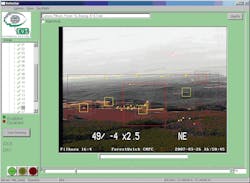
To accomplish quick detection of wildfires, the first step in the process is to run video through an image stabilization algorithm, average and subject it to an image quality control process at the remote site by the ForestWatch ISE (Image Sampling Engine). High bandwidth links allow for the live video to be displayed at frame rates of eight images per second without any compromise to image resolution.
Once a potential fire has been spotted, the system can alert responsible parties via the internet, cell phone, pager, and landline. Multiple parties can be notified by the same site, providing redundancy in case the primary party is indisposed.
Custom Mapping
As part of an EVS installation, detailed information on the area under surveillance is included in the customized software package. As a result, the actual infrastructure can be identified in the camera views provided, known objects which might cause false alarms can be taken into account, and the system can be set up in such a way that a captured daytime photo can overlay a nighttime image to better discern what fire agency personnel are actually looking at. Names of certain features and structures can be included in the displayed image to help identify landmarks for emergency responders.
Eyes In The Dark
Many wildfires start at night, when there is a higher risk of no one detecting them or of resources being dispatched to the wrong location in the dark. Since many fire agencies do not actively patrol for fires, depending instead on calls from the general public, they are less likely to detect a wildfire that occurs in the late night or early morning hours until it grows to an unmanageable size. In fire-prone areas like Southern California, even five minutes can make all the difference between a blaze being tackled as a spot fire or turning into an $80 million monster.
ForestWatch systems offer a nighttime benefit no lookout could provide. Their sleepless cameras scan the horizon day or night, and their near-infrared capability means that they are capable of localizing flame fronts not visible to the human eye through the smoke and haze. This allows ForestWatch operators to spot smoke plumes in hazy conditions before flames are even visible. And since fire dispatch centers typically operate 24/7, alerts from ForestWatch systems allow these dispatchers to quickly mobilize a response, with the added benefit that they can zoom in on an incident to determine precise size and location of a blaze, greatly aiding an incident commander’s size-up of the fire before resources are dispatched.
Portability
Unlike a lookout tower, an EVS camera can display images anywhere there is an available computer via the internet. This gives first responders unparalleled capabilities, allowing them to monitor an incident as they approach in case the situation changes. With the ability to pan/tilt/zoom any camera in the network, an incident commander can slew a camera over to a specific location, zoom in on something, and determine the best course of action to quickly knock down the fire.
Force Multiplier
The military uses the term “force multiplier” to signify how technology can increase the effectiveness of available assets. ForestWatch is a force multiplier, in that it allows incident commanders to allocate just enough of their limited firefighting resources to an incident, keeping enough in reserve for other emergencies. By having cameras strategically located, they can cut down on the unknowns associated with responding to an incident as well. In an era of budget cuts and firefighter layoffs, ForestWatch systems allow a fire agency to do more with fewer resources.
Arson Prosecution
Another feature of the EVS equipment is the ability to archive data from an incident for use in prosecution of arsonists. With date/time stamping on each frame of video from an EVS camera, law enforcement can provide incontrovertible evidence at trials of arson suspects, something no lookout tower could ever do!
And the same record-keeping capabilities can also be used to collect fire data for comparison with historical Fire Regime Condition Class information, a useful feature when trying to assess the effectiveness of a fire agency’s policies in an era of climate change.
Field-Tested: DFPA
Douglas Forest Protective Association (DFPA), headquartered in Roseburg, OR, has deployed dozens of wildfire camera systems across the state. Their dispatch center is state-of-the-art, with monitors able to quickly switch from one trouble spot to another and convey up-to-the-minute information to firefighters as they respond to an incident. What started out as a small operation for a limited area has now expanded to include many locations spanning a large swath of the state.
Melvin Thornton, the DFPA District Manager, had this to say about the system: “We have been very pleased with the ForestWatch system and EVS’s response to issues when they develop. They listen to our needs and then work to solve the issue or to improve efficiency.”
And EVS also customizes systems to the customer’s specifications. “An example where EVS took an idea and made it work was incorporating lightning strike data onto our maps so the operators would know where active lightning was occurring, helping to find fires earlier,” said Thornton. “The ForestWatch 3 software provides more than just detection capabilities, it provides fire managers an immediate view of the fire, location, and it’s potential to increase. Then we use that information to prioritize fires during periods of multiple fire events.”
For more information on ForestWatch, visit http://www.evsolutions.biz.
Summary of Envriovision Solutions Systems Features
Wildfire Camera
- High-powered 35x optical zoom lens
- 15-mile visual range (with zoom)
- 18 preset views per 360-degree rotation
- High stability in windy conditions Effective low-light level performance at night
- The ability to switch to a near IR (Infrared) mode during the day to see further in hazy or smoky conditions
- The ability to switch back from “night shot” to color at night with long exposure mode active
Geo-referencing Software
- Geo-referencing is a key advantage due to the impact it has on making the algorithms “range aware”
- Results in better detection
- Lower false-alarm rates
- Improved situational awareness when dispatching resources to known locations
- Can overlay stored daytime images onto live night image for better context and interpretation of how the fire propagates at night
Methods of Notification
- Pager
- Cell Phone
- Internet
- Landline
- Multiple recipients can be designated
Videofeed Time Stamping
- Date and time stamps
- Pan, tilt and zoom settings
- Camera preset view number
- Site name
- The image shift required to stabilize the image as the sway/wind increases Law enforcement and arson prevention application Arson investigation and courtroom evidence
About the Author
Billy Goldfeder
BILLY GOLDFEDER, EFO, who is a Firehouse contributing editor, has been a firefighter since 1973 and a chief officer since 1982. He is deputy fire chief of the Loveland-Symmes Fire Department in Ohio, which is an ISO Class 1, CPSE and CAAS-accredited department. Goldfeder has served on numerous NFPA and International Association of Fire Chiefs (IAFC) committees. He is on the board of directors of the IAFC Safety, Health and Survival Section and the National Fallen Firefighters Foundation.