Wildland Fire Behavior: A 'Tune-up' for Structural Firefighters
The intent of this article is to "tune-up" your understanding of wildland fire behavior. Understanding fire behavior allows for the correct selection of strategy and tactics. Similar to structural firefighting, knowing where the fire is, how it is behaving, and where it is going are critical. Also, anticipating how the fire will react once it gets to your location allows for safer engagement of the fire.
A wildland fire that threatens structures can become the interface fire. Sometimes the "interface" itself is the entire fire area. Common factors are the vegetative fuels (wildland and ornamental), weather, and topography. Once the fire enters the immediate area around structures, yard debris, outbuildings, and the structures themselves contribute to the fire behavior. In a report published by NWCG, 50 percent of engine burnovers occurred on interface fires.
Safety depends on your ability to:
- Determine the potential worse case scenario of current and expected fire behavior
- Determine how much time you have before the fire arrives.
- Determine when and where you will be in danger of entrapment.
Fire researcher Carl Wilson, in his article "Fatal and Near-Fatal Forest Fires: The Common Denominators," published in The International Fire Chief in 1977 discussed four common denominators of fire behavior that caused fatalities and near-misses on wildland fires:
- On relatively small fires or deceptively quiet areas of large fires.
- In relatively light fuels, such as grass, herbs, and light brush.
- When there is an unexpected shift in wind direction or wind speed.
- When fire responds to topographic conditions and runs uphill.
These continue to be applicable today. Particularly noteworthy is the first common denominator as it more closely resembles a human behavior factor. In other words, the fire itself does not need to be of great size or intensity for it to injure or kill. When you assess fire behavior and determine the facts presented, a logical and safe course of action needs to follow. If all the factors tell you to disengage from the current operation, your approach needs to honor that thought. The situation may dictate that you seek a more advantageous point of engagement.
Wildland Fire Behavior Factors
Fuels, weather, and topography create fire behavior. The factors below, taken from the Incident Response Pocket Guide (IRPG), must be visually noted. These are then evaluated so a more accurate determination of the resulting fire behavior can be predicted.
Fuel
- Continuous fine fuels to heavy loading of down & dead
- Ladder fuels in brush & timber
- Tree spacing of under 20 feet or numerous snags which can serve as firebrand senders and receptors
- High dead-to-live ratio from frost or bug kill
- Preheated fuels
- Drought stressed or old aged fuels
- Normal seasonal dried fuels
- Fuels in direct sunlight
Weather
- Low relative humidity
- High temperature
- Moderate to high wind speed, (foehn, general, and localized/terrain),
- Approaching thunderstorms (tall, building cumulus clouds)
- Approaching cold fronts (cirrus clouds, sudden calm, battling or shifting winds)
- Unstable air mass (clouds and smoke grow vertically to great heights, cumulus-type clouds, gusty winds, good visibility, presence of dust devils and firewhirls, inversion lifts)
Topography
- Steep and gentle slopes
- Chutes
- Chimneys
- Saddles
- Narrow and box canyons
Emergeing Extreme Fire Behavior Indicators
- Smoke column is well-developed and could be leaning or looks blown out
- Trees are torching and throwing embers (spotting)
- Large areas of ground/surface fuels are on fire
- Firewhirls appear
- Smoldering fires are waking up
- Inversion has lifted out
- Terrain winds have increased
Note: Relative humidity, temperature, and wind speed thresholds have been published within the "pocket cards" which are available from the federal land management agencies.
Interface firefighting by nature is normally a defensive action since unburned fuel exists between the fire and your position. If the fuels are already burnt, they must be carefully examined to determine their potential to re-burn. This is a very important consideration, especially if you are utilizing the burned area for a safety zone.
The Campbell Prediction System
The interface fireground does not always allow you the opportunity to visualize the behavior of the fire. Therefore a quick and simple way of predicting potential fire behavior is necessary to create a safer firefighting experience. The Campbell Prediction System (CPS) was created by Doug Campbell during his 40-year U.S. Forest Service career. This system utilizes three fireline factors/forces to determine fire behavior potential. The following is a highlight of CPS which should be integrated into your understanding of the fire behavior factors listed above.
Three fireline forces are accessed to determine changes in fire behavior:
- Wind
- Slope
- Solar preheating of the vegetation (fuel temperatures on a hot dry sunlit slope can reach temperatures near 180 degrees. Ignition of these fuels is usually less than 500 degrees).
Note: CPS does not utilize relative humidity and temperature, but these are important fireline factors that must be included in your overall assessment.
The Alignment of Forces
Wind, slope and pre-heat are causes of fire intensity. One force misaligned or in alignment with another cause variations in that intensity. The questions that need to be asked to determine the potential are:
- Will all three align?
- At what time of day will they align?
- Where will they align?
All three forces in alignment yield the maximum potential fire behavior, but the maximum potential can be difficult to comprehend. Therefore just knowing that the structure you are assigned to defend is located atop a south-facing slope with fire below should trigger some serious concerns for your safety.
Predict The Future Using CPS
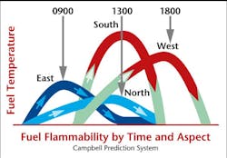
If you are able to watch the fire burn from one slope to another, note the effects of different wind speeds, and then see what happens when it burns from shaded fuels to sunlit fuels, you would have a pretty good idea of the potential. Unfortunately you are not always able to visualize how the fire is burning, especially in a timbered interface area. This is one more reason to have multiple lookouts posted to watch the fire. Figure 1 is used to determine where in space and time you are on the fuel flammability curve. Southeast, south, southwest, and west-facing slope fuels will have the highest fuel temperatures. Once again, working above a fire on a west slope, in the afternoon, with a west wind should send alarms going off in your head.
Now apply basic wildland fire behavior, augmented with CPS, to the interface fire represented in Figure 2. The fire is in a position to take advantage of the forces. Remember, safety depends on your ability to determine the potential worst-case scenario of current and expected fire behavior, how much time you have before the fire arrives, and when and where you will be in danger of entrapment.
Most of the structures on the ridge top are being affected by two of the forces (wind and slope). In most situations this would be enough to warrant a hard look at the assignment. Are there safety zones adjacent to the structures, and can you maintain lookouts, ommunications, escape routes, safety zones (LCES)? By referencing the Fuel Flammability Chart, you see that the third force (solar pre-heating) will be a factor for most of the day at some point along the ridge. You know the southwest slopes yield the highest fuel temperatures, therefore 1400 hours would be a likely time to expect a run by the fire. You know this is a highly probable fire run, therefore ensuring that you can maintain LCES is mandatory, not an option.
Time Tag The Run
In this example 1400 hours would not be a good time to be working along the ridge above those southwest slopes. A "time tag" (pre-determined time that the planned event is valid) of 1300 hours would be recommended to disengage from the exposed areas. If you have safety zones in the area, you can continue to work, just not on top of those exposed slopes. If there are no safety zones, the amount of equipment and personnel that are assigned to that ridge need to be closely monitored. The key here is to determine where and when it is safer to have resources committed. "Safer" does not mean completely safe. The fire environment can never be made 100 percent safe, but the use of some basic principles help make it safer.
Tactical Maps
CPS helps to identify where the fire will get into alignment, thus becoming a life-threatening problem. Interface fires normally staff a large amount of resources, therefore the possibility of sitting in staging and then deploying to a hazardous situation in a short amount of time is very real. Creating a "tactical map" from your CPS knowledge does not take much time. Using a topographical map and a writing instrument (highlighter, pen, pencil, crayon) highlight the potential hazard areas so they are visible when time is short. Be sure to note the alignment-of-forces tracks and time-tag to show when the safer times to be in those areas is.
Thinking back to Carl Wilson's four common denominators of fire behavior that cause fatalities and near-misses, you now have knowledge which can help you operate more safely. But the common denominator that more closely resembles a human behavior factor is still the one which can present the most trouble. The information here is basic and foolproof, unless you choose to ignore what the facts are telling you.
- See author Quinn MacLeod Live at Firehouse World! Quinn will be presenting "What Did You Say? Managing Risk Through Improved Communications" at Firehouse World in San Diego, Feb. 28 - March 4.
QUINN MacLEOD is the owner and lead instructor of Integrated Fire Solutions, and has been in the fire service since 1985, including 20 years on the line with the Parker, CO, Fire District. He is also NWCG qualified as a wildfire Division Supervisor and holds a Fire Science Associate's Degree and numerous state and national certifications, including fire officer and fire instructor. You can contact Quinn by e-mail at: [email protected]. RICK LYNSKY currently works as a battalion chief for the City of Montebello, CA, Fire Department. He started his fire service career in 1982 and has an AS degree fire science and a BA in Public Administration. He is NWCG qualified as a Division Supervisor and Structure Protection Specialist. You can contact Rick by e-mail [email protected].
About the Author

Quinn MacLeod Rick Lynsky
For Firehouse.com
Quinn MacLeod, owner and lead instructor of Integrated Fire Solutions, has been in the fire service since 1985, which includes 20 years on the line with the Parker Colorado Fire District. He is also NWCG qualified as a wildfire Division Supervisor and holds a Fire Science Associate’s Degree and numerous state and national certifications, including Fire Officer and Fire Instructor.
Rick Lynsky currently works as a Battalion Chief for the City of Montebello Fire Department in Southern California. He started his fire service career in 1982 and has an AS degree fire science and a BA in Public Administration. He is NWCG qualified as a Division Supervisor and Structure Protection Specialist.
