Station Design: A GIS Approach to Fire Station and EMS Projects
Technology and the data it collects can play a big role in the beginning stages of fire station design when it comes to selecting the best site location for the community’s emergency responders.
The use of Geographical Information Systems (GIS) is gaining popularity by fire departments and architect researchers to use data that’s been collected and create overlays for maps to understand response needs and pinpoint the best location for a new fire station.
Project Manager Michael Clark and GIS Manager/Analyst Heather Lewis, with Five Bugle Designs, looked at these factors during the “A GIS Approach to Fire Station and EMS Projects” session at the 2018 Station Design Conference.
Growing trend
In the past, Clark said fire departments would either building a new station at an existing location, or eyeball a plot of land that would be considered suitable for a station, but later find out it was not the best spot.
“Most projects are doing station location studies (using GIS) as a way of locating their facilities now,” Clark said.
“If we’re making a presentation to the city council and someone doesn’t understand our map, we can change the map from street map of the city to an aerial view of the city so they can see all the streets and landmarks,” Clark said, adding that it provides a much more powerful visual.
Clark cautioned that using GIS analysts who don’t focus on public safety projects may not understand some of the intricacies, such as mandated response times or the importance of equipment near certain hazards.
“What we bring to the discussion is a level of understanding of the issues the fire service has so we can help create a mapping story,” Clark said. Golf courses, parks or lakes can increase response times, but also those data points on maps may show the need for specialized resources to be located in a different place.
“Think fire calls,” Clark said, “We can take all the addresses of fire calls over the last three to five years and take that digital data and turn it into a map.”
The data
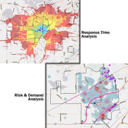
A team of Emergency Services Specialists from his firm collects up to 20 criteria into categories, including streets and speed limits, population densities, traffic hot spots, target hazard locations, call volumes and response times. In the case of volunteer departments, the data can show the best place to locate a fire station based on the firefighter’s residences and response times.
The data can be collected from cities and counties, and when the firm’s team hits the streets, they can use their phone to input critical data right into the program, such as hazardous materials or endangered structures.
Those factors can be computed and mapped to compare with NFPA 1710 and 1720 and Insurance Services Organization (ISO) response time requirements.
Case study: current locations
“Every community has a different reason for moving their fire stations or looking at a new location,” Clark said.
The first of two case studies that Clark and Lewis discussed involved a city in the Midwest that was looking at the existing location of their fire station as the community grew.
“The question is, ‘This has been sitting here for 40 years, is it in the right place?’” Clark said of the first discussion his staff had with the fire department.
They created custom GIS maps that included community hazard locations, population densities and where fires had been over previous years. Those maps were overlaid on land-use maps that showed where the community planned to grow.
After analyzing the data, it was determined that the location for the station was only a half-mile away and the committee determined that the costs would not be worth it.
The project resulted in a renovation of the existing station.
The community did receive side benefits, Clark said, noting that an area where regulations said plots needed to be over six acres could be removed. It the regulation changed, the population density would grow and that would mean the existing station isn’t in the correct location.
Also, while the community considers replacing a bridge that is no longer in use, a new bridge would encourage development and again, the station would not be in the best location.
“Now the chief has that map and when he goes to city council meetings, he can pull that out and show them where resources are needed as the city changes,” Clark said.
Case study: Growing community
The session included a second case study of a Midwestern city where both stations are located alongside a busy rail line and the community has developed as the population grew. The chief felt the two-station deployment model was outdated and wanted to determine the next steps.
When the stations were built, one medium-length train passed through the community daily. Now, four long trains hauling crude oil and natural gas pass through, slowing response times because both stations are in close proximity to the tracks. Two highways and a river create additional response barriers.
Clark said the main factors for the study were response times. This included the time needed by firefighters to travel to the station to respond and then response times by apparatus from the stations into the community.
When Clark’s team was there to collect information for the project, a call was dispatched and they followed that firefighter. The firefighter’s response time was over 10 minutes, which showed that many of the responders were slowed by traffic and the trains, showing the need for a third station to meet the response requirements.
“So the GIS study created a series of maps and showed them to the council, and they are considering the third fire station because of the challenges,” Clark said.
“One of the things I try to make sure chiefs understand is that if there is question, it will get asked and you need to have an answer,” Clark said of the GIS program.
Clark called the process “mapping a story.”
About the Author

Peter Matthews
Editor-in-Chief
Peter Matthews is the editor-in-chief of Firehouse. He has worked at Firehouse since 1999, serving in various roles on both Firehouse Magazine and Firehouse.com staffs. He completed an internship with the Rochester, NY, Fire Department and served with fire departments in Rush, NY, and Laurel, MD, and was a lieutenant with the Glenwood Fire Company in Glenwood Landing, NY. Matthews served as photographer for the St. Paul, MN, Fire Department and currently is a photographer for the Fort Worth, TX, Fire Department.