Fire Technology: Hazmat Response—Drones Are a Necessity
Hazmat incidents are among the most dangerous and most challenging responses for public safety agencies. These incidents often involve a number of unknowns, including but not limited to substance involved (chemical, biological, radioactive, nuclear, explosives), cause of the problem, and the environmental dangers to people and responders. Hazmat responses usually require fully encapsulated protective suits that have SCBA and call upon firefighters to enter an unknown and potentially dangerous environment. These operations usually can’t be monitored visually, and communication is limited to verbal radio communications. Additionally, if a tool is needed during the operation, it requires one of the technicians to go to the “Warm Zone” to get it or to have another technician bring it to the site, which increases the overall time to mitigate the incident. (Equipment that’s identified as needed can be pre-loaded.) Also keep in mind that when the hazmat mitigation process is underway, the facility and nearby roads might be required to be shut down for hours or, sometimes, days.
Drones make a significant difference, such that mitigation might be improved dramatically, which enhances safety and reduces time, which allows roads and facilities to be re-opened more quickly.
Game changer
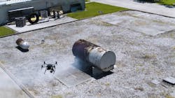
Upon arrival, a drone can be launched within minutes to provide aerial reconnaissance and remote hazmat monitoring/identification of an environment that is immediately dangerous to life and health. This combines with the capability to: quickly identify injured persons; determine exposure issues; and even determine the problem (leaking/ruptured tank, broken valve, fire/flame impingement, structural integrity, direction of spill flow, etc.). The latter provides invaluable information regarding the dangers to personnel and the identification of the proper protective suits and tools that are required, to more effectively mitigate the incident.
All of this can be done while operations and decontamination are being established while keeping firefighters out of harm’s way unnecessarily.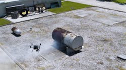
Drones that are equipped with thermal imaging cameras can identify heat signatures, which can show existing ignition sources and display liquid levels in hazmat containers. They also can: visualize an otherwise invisible dangerous vapor cloud or plume; see the effect of flame impingement on a tank, which could lead to a catastrophic boiling liquid expanding vapor explosion; and see heat signatures of responders and injured persons at night or in situations in which smoke might obscure vision.
A drone can be used to observe the effectiveness of suppression operations and to direct the application of extinguishing agents more effectively via both visual optics and thermal imagery. This information can help to identify conditions that require evacuation of people who are or could be in danger.
Hazmat spills can be monitored as to their direction of travel and sheen on the water as well as in regard to the effectiveness of containment efforts.
Use of a drone for overwatch can alert personnel to potentially changing and dangerous conditions that might escape the awareness of hazmat technicians. Video streaming can be provided (on scene or wherever necessary) for real-time situational awareness.
A drone that’s equipped with a speaker can be utilized for additional warning, which might be critical should traditional radio communications be ineffective.
A hazmat-monitor-equipped drone can be landed and serve—rotors turned off—as a “perched” remote hazmat sensor for hours. A drone can deliver a needed tool nearby to the operation. With an add-on light, it can help to illuminate a dark area whether during day or night operations.
Visual imagery can be captured and be converted into a 3-D model to evaluate later. The same imagery can provide damage assessments, which might be shared with the media and the community as appropriate.
Train derailments often occur in remote rural areas. A drone can be launched quickly to see the magnitude of the derailment and the number of cars that are involved. A drone can be used to determine whether there is fire, whether hazmat cars are present/involved and whether there is a spill or release. Placards can be read, and nearby exposures (people, homes, schools, etc.) can be identified. For transportation accidents, a drone can fly over and around the incident to read placards and even to see into an open box trailer.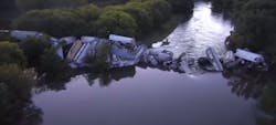
A department to emulate
Southern Manatee, FL, Fire and Rescue (SMFR) is the pioneer and leader in the use of drones for hazmat response. For example, during a difficult sulfur fire (hot, toxic and obstructed view) and an anhydrous ammonia leak (extremely volatile and toxic), SMFR used a drone to provide initial situational assessment via a full 360-degree overhead view of the area. In such circumstances, the critical assessment that can be made can ensure that the situation is safe enough for firefighters to enter, to pinpoint the specific problem and to identify plumes or other existing conditions that will affect the firefighters.
During the sulfur fire (which was their a-ha moment on hazmat drones), SMFR was able to identify hot spots with a drone that otherwise would have been nearly impossible to do. During the anhydrous ammonia leak, a drone’s thermal imaging camera identified the source of the leak, which was invisible to the naked eye.
These and other hazmat responses led to SMFR’s policy to always launch a drone at the first stage of a hazmat incident and to operate a drone throughout an incident to monitor/identify substances, provide overwatch of operations, deliver tools if necessary, provide lighting and serve as backup communications.
Volcanoes and meltdowns
During the most recent volcanic activity in Hawaii, drones monitored new fissures and lava flows as they formed and their proximity to homes and people. Drones that are equipped with sulfur-dioxide sensors were flown to identify the presence of and direction of toxic gaseous clouds (otherwise invisible) to evacuate people to areas of safety. They also were used for damage assessment and situational awareness.
At the Fukushima Daiichi nuclear power plant disaster site, drones measured radiation and determined areas of danger. Later, they were used to determine residual effects, as they were at the site and nearby to the Chernobyl disaster. If the drone is contaminated, it can be disposed of.
Drones provide great value for training and after-action reports. Hazmat incident imagery and video can identify lessons learned and teach responders how to improve during future responses. Training activities/simulations can be videorecorded and reviewed at a later time for teachable moments.
Pre-fire plans of major facilities and critical infrastructure can be enhanced by drone imagery and 3-D modeling. Invaluable information as to facility map, access, features, hazards and suppression resources of chemical plants, bulk oil facilities, ethanol refineries, railroad yards and nuclear power plants can be gleaned.
From a facility perspective, drones can fly to do periodic safety/security inspections to identify anomalies, unauthorized persons in secure areas, leaks and/or fires as well as to inspect areas that are too difficult and/or dangerous to access.
The use of drones by departments, such as SMFR, has proven the devices’ undeniable value to enhance safety, improve operational effectiveness and provide real-time situational awareness. Drones are a must-have for hazmat teams.
About the Author
Charles Werner
CHARLES WERNER is a 45-year veteran of public safety. He served with the Charlottesville, VA, Fire Department for 37 years, serving the last 10 years of his tenure as chief. Following retirement, Werner served for two years as senior adviser and acting deputy state coordinator for the Virginia Department of Emergency Management. He has chaired: DHS SAFECOM Executive Committee; IAFC Technology Council; National Information Sharing Consortium; and DHS/White House Incident Management Information Sharing SubCommittee. Werner currently serves as the director of DroneResponders Public Safety Alliance, chair of the National Council on Public Safety UAS and chair of the Virginia Secure Commonwealth UAS Sub Panel.