How GIS, Advanced Communications & Predictive Modeling Are Transforming Fire Department Disaster Response
Key Takeaways
- GIS, advanced communications and predictive modeling are reshaping how fire departments prepare for, respond to and recover from hurricanes and wildfires.
- GIS allows fire departments to visualize vulnerability before a hurricane or wildfire strikes.
- The integration of GIS, advanced communications and predictive modeling into a unified system provides decision-makers with a complete, real-time picture to enable faster, smarter and more-coordinated responses.
Disaster response is a race against time. Hurricanes and wildfires, in particular, demand swift, coordinated, and informed actions to save lives and protect infrastructure.
Historically, emergency responders relied on scattered data, delayed forecasts, and limited communication channels to organize evacuations and deploy resources. Although courage and coordination always have defined disaster response, today, technology has become the force multiplier that enables responders to act smarter, faster and more efficiently.
Three technological domains stand out for the positive effect that they have: geographic information systems (GIS), advanced communications and predictive modeling. Together, these tools are reshaping how agencies prepare for, respond to and recover from the twin threats of hurricanes and wildfires. By transforming raw information into actionable intelligence, they allow responders to anticipate the effects of disasters, adapt strategies in real time and coordinate across jurisdictions like never before.
Mapping in real time
GIS no longer is a niche mapping tool. It’s a core element of disaster response that allows fire departments to visualize vulnerability before disaster strikes.
For hurricanes, GIS platforms allow agencies to overlay storm surge models, flood plain maps, population density and evacuation routes. This helps officials identify which neighborhoods are most at risk, where to pre-stage resources and how to plan evacuations that minimize congestion.
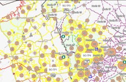
For wildfires, GIS provides hazard maps that track vegetation density, drought conditions and topography, which are factors that determine fire risk. Preseason mapping allows emergency managers to identify vulnerable communities, plan fuel reduction projects and create defensible spaces around critical infrastructure.
When Hurricane Ian made landfall in Florida in 2022, GIS dashboards displayed real-time storm surge levels, shelter availability and road closures. First responders used these maps to prioritize rescues, while utilities mapped outages to speed up power restoration. During California’s 2020 wildfire season, GIS platforms integrated fire perimeter updates, satellite imagery and weather forecasts into live dashboards, which gave commanders instant situational awareness.
After disasters, GIS continues to add value. Damage assessments are mapped to visualize the scale of destruction, which helps to guide federal aid and local rebuilding priorities. For hurricanes, GIS data highlights repeatedly flooded areas, to inform flooding buyout programs and infrastructure upgrades. After wildfires, GIS tracks soil burn severity and guides erosion control measures to prevent mudslides.
Agency & community links
Communication breakdown long has been a hallmark of disaster failures. In the past during a hurricane, local, state and federal agencies operated on incompatible radio systems. Further, during early wildfire responses, responders often relied on word-of-mouth updates and/or handwritten logs.
Today, interoperable communication systems and advanced digital platforms dramatically reduce those barriers. Modern radio systems allow responders from multiple agencies (e.g., firefighters, police, EMS and the National Guard) to communicate seamlessly. During Hurricane Harvey in 2017, interoperable radios enabled dozens of agencies to coordinate water rescues. In wildfire-prone states, mutual-aid deployments from out-of-state crews now integrate smoothly into communication system frameworks.
When hurricanes knock out cell towers and when wildfires destroy fiber optic lines, satellite phones and mesh networks keep responders connected. After Hurricane Maria struck Puerto Rico, satellite communications became the backbone of response operations. In wildfire operations, fire camps now rely heavily on satellite internet for planning and coordination.
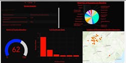
Cloud-based digital incident management platforms, such as Search & Rescue Common Operating Platform (SARCOP) and WebEOC, have replaced paper logs. During hurricanes, such platforms track shelter capacity, resource requests and evacuation progress. During wildfires, they integrate GIS fire maps, weather forecasts and crew assignments. This transparency allows for rapid, data-driven decision-making.
Also of note, agencies now leverage social media to issue evacuation orders, dispel misinformation and update residents on changing conditions. Hurricane Florence in 2018 demonstrated the effectiveness of using Twitter (now X) and Facebook for flood warnings. California’s Camp Fire highlighted the speed and necessity of social media alerts in evacuation efforts.
Before disaster strikes
Predictive models have revolutionized hurricane forecasting. The National Hurricane Center’s Hurricane Weather Research Forecast (HWRF) model integrates satellite data, sea surface temperatures, and atmospheric patterns to project storm paths and intensities with increasing accuracy. Better modeling means more lead time for evacuations and targeted actions.
Wildfire modeling tools simulate how a fire will spread over hours and days, considering wind speeds, humidity, vegetation and slope. In 2020, Oregon officials issued evacuation warnings that were based on predictive models hours before flames reached towns. Models also guide suppression tactics, to turn reactive firefighting into proactive risk management.
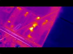
The greatest advances come from merging predictive models with live feeds. For hurricanes, real-time data from buoys, radar and reconnaissance aircraft improve forecasts. For wildfires, drone and satellite data recalibrate spread models, which ensures that forecasts remain relevant as conditions evolve.
Integration
The real breakthrough isn’t in any single technology but in their convergence. Modern disaster response integrates GIS, communications and predictive modeling into a unified system.
During hurricanes, storm surge models project flooding depths, which GIS maps visualize for evacuation planning. Radios and satellite networks coordinate responders, while public alerts ensure that residents act quickly.
During wildfires, drones capture perimeter data (feeding GIS), which updates predictive models of fire spread. These updates are shared through incident management systems (communications) and pushed to the public via alerts.
This integration ensures that decision-makers have a complete, real-time picture, to enable faster, smarter and more-coordinated responses.
Challenges and limitations
Despite their promise, these technologies face challenges:
- Equity of access. Smaller jurisdictions might lack funding to adopt advanced tools. Partnerships might be a solution to this. Partnering with a local university that has a program that specializes in technology, such as drones or GIS, can be a way to access technology that one’s department lacks. Interns from one of these programs can be a valuable resource to help bolster staffing needs.
- Cybersecurity. Increased reliance on digital platforms creates vulnerabilities to cyberattacks. Working on the front with your department’s IT group or that of your municipality end helps with this. Present the problem to the IT people first and let them help to construct the solution.
- Training. Technology requires skilled operators; agencies must invest in personnel training. There are many opportunities online to learn that cost little to no money. There also are multiple opportunities at conferences that provide this training. Sending one or two members to a conference allows those people to bring back what they learned to teach others.
- Redundancy. Hurricanes and wildfires can disable networks and infrastructure. Having the capability to have a failsafe is paramount in our profession. As advanced as we are and continue to be in our technology, we never must lose the capability to function in the analog world, to guarantee that we have our own continuity
plan to ensure that the mission continues, no matter what it is.
New era
Technology has transformed disaster response to hurricanes and wildfires, turning chaos into coordinated action. GIS maps provide clarity, predictive models deliver foresight, and communication systems keep agencies and citizens connected.
As climate change fuels more intense hurricanes and longer wildfire seasons, these tools are necessities. The integration of GIS, communications and predictive modeling has created a new era of disaster response, defined by foresight, coordination and precision. Ultimately, technology just doesn’t modernize disaster response; it saves lives, protects communities and strengthens resilience for the future.
About the Author

Chad Beam
Chad Beam has nearly 20 years of experience in fire, EMS and emergency response. He currently is an assistant chief of South Carolina State Fire, where he oversees the state’s Emergency Response Division, including Urban Search and Rescue, the South Carolina Helicopter Aquatic Rescue Team and firefighter mobilization statewide. Beam has deployed as operations section chief on more than 20 federally declared disasters. He also serves a part-time firefighter with the Fountain Inn, SC, Fire Department, where he has been a member for 14 years. Beam serves as second vice president of the State Urban Search & Rescue Alliance and vice chair of the National Search and Rescue Geospatial Coordination Group. He holds a bachelor’s degree in emergency services management from Anderson University and a master’s in public administration from Clemson University and is enrolled in the Executive Fire Officer Program at the National Fire Academy.