How DFR Changes Fireground Situational Awareness for Firefighters, Company Officers & Incident Commanders
Key Takeaways
- For fire departments, the value of the implementation of a Drone as First Responder (DFR) program is immediate: faster size-up, earlier recognition of exposures, better resource allocation, improved responder safety, and live visual and thermal information that can support decisions from dispatch through termination.
- The use of DFR by fire departments supports ongoing scene size-up. A drone can continue to monitor fire extension, crew progress, collapse indicators, search areas, traffic conditions, evacuation zones and damage-assessment needs.
- The role of remote tactical flight operators is more than simply watching a drone feed. They monitor 9-1-1 activity, evaluate calls against deployment criteria, launch drones, interpret what the aircraft see, communicate with responding units and support the incident commander with timely information.

When the first few minutes of an incident are filled with uncertainty, the quality of the earliest information matters. A reported structure fire might be a working fire, an exterior fire that threatens exposures or something much smaller than what the initial dispatch suggests. A technical rescue, hazmat incident or large-scale emergency might require an incident commander (IC) to understand the scene before crews can gain access safely.
Louisville Metro’s Unified Drone as First Responder (DFR) program was built around a simple premise: get reliable visual information to responders before they arrive and keep that information flowing as the incident evolves.
The program brings together the Louisville Fire Department (LFD), Louisville Metro Police Department, Jefferson County, KY, Fire Service, emergency management, EMS and MetroSafe 911 under a shared public safety technology model. For the fire service, the value is immediate: faster size-up, earlier recognition of exposures, better resource allocation, improved responder safety, and live visual and thermal information that can support decisions from dispatch through termination.
How deployment works
DFR deployment begins in the communications environment. Eligible keywords that are flagged by an artificial intelligence transcript of the live 9-1-1 call alert the remote operations center (ROC) team through the 9-1-1 and RapidSOS workflow. That integration is critical. If a drone launch depends on a separate manual request after units already are on scene, the program loses much of its first-responder value. The power of DFR is in shortening the time between call receipt and actionable visual intelligence.
The remote tactical flight operator (rTFO) who staffs the ROC reviews the call transcript, determines whether launch criteria are met and sends the nearest available drone from a dock toward the incident. This all takes place within approximately 30–60 seconds of the call being received, while the call still is being processed and hasn’t been dispatched.
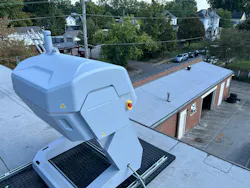
DFR drones fly autonomously to the location of the 9-1-1 call, stopping 600 feet short of the center of the address. The rTFO then takes over operation, transmits an initial size-up and monitors the incident from overhead.
The initial objective is to establish a visual size-up as early as possible. Once airborne, the drone provides live video with thermal imaging capabilities from an overhead view of the scene. The rTFO then translates that aerial picture into operationally useful information. For fire calls, this might include confirming smoke or fire conditions; identifying the involved structure or exposure; checking access routes; looking for occupants; evaluating roof conditions; identifying utilities or hazards; or determining whether the incident appears smaller or larger than initially reported.
For technical rescue or water rescue incidents, the drone might help to identify victim location using its laser rangefinder that provides global positioning system (GPS) coordinates; access points; hazards; or the safest route for crews.
For hazmat or transportation incidents, the drone might help command to assess plume movement, container involvement, negative effect on traffic and isolation needs.
Because the system is shared across fire, police and EMS, the same platform can support different missions while preserving each agency’s operational responsibilities.
The key is that the drone feed doesn’t remain trapped in the ROC. Information is relayed to the IC, responding members and officers through established communications paths. For the LFD, the link to the live feed is available in the Tablet Command CAD interface, to which all members have access on their emergency vehicle-mounted iPad or their personal device. The rTFO can provide plain-language updates over radio to give responders a better picture of the scene before they commit.
DFR also supports ongoing scene size-up. The first view is important, but incidents change. A drone can continue to monitor fire extension, crew progress, collapse indicators, search areas, traffic conditions, evacuation zones and damage assessment needs. It can provide pin drops for victims, search locations, hazards and damage assessment points. It can help command to maintain a broader view while companies and officers work at ground level.
Adding to the 6-16-60
Firefighters often operate from what could be called a six-foot perspective: the immediate area around them, the conditions that they can see, feel and hear, and the hazards that directly affect their task. A company officer works from a broader 16-foot perspective, focused on the crew, the members’ positions, their progress and the safety of the area around them. The IC has a 60-foot perspective, standing back from the incident, reading the building, tracking assignments and making strategic decisions. DFR adds another layer: the 600-foot perspective.
From above the incident, a drone can provide responding companies and ICs with a view that they can’t get from the street, the front yard, the command post or the interior.
The 600-foot perspective doesn’t replace the firefighter’s six-foot view, the company officer’s 16-foot view or the IC’s 60-foot view. It connects them. It gives everyone a better shared understanding of the same incident, from the firefighter who’s engaged in suppression operations to the IC who’s making strategic decisions.
Staffing the ROC
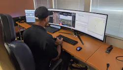
The ROC is the operational hub of the DFR program. Louisville recently added three rTFOs to staff the ROC 24/7/365 and is in the process of hiring two more.
The rTFO role is more than simply watching a drone feed. The rTFO monitors 9-1-1 activity, evaluates calls against deployment criteria, launches drones, interprets what the aircraft is seeing, communicates with responding units and supports the IC with timely information. The rTFO must understand public safety operations and the incident command system (ICS) well enough to know what matters, what must be relayed immediately and what information could change the response. Minimum qualifications for rTFOs are three years of public safety experience, a Federal Aviation Administration (FAA) Part 107 Remote Pilot License, and ICS 100, ICS 200, ICS 700 and ICS 800.
As the program grows, remote pilots will be hired to supplement the rTFO. They’ll be required to have FAA Part 107 but not public safety experience.
They’ll support mission execution and routine aircraft operation; rTFOs will focus on tactical decision support, mission prioritization and communications with responders.
Louisville received an FAA waiver that enables each pilot to operate as many as four drones simultaneously. That waiver is a major force multiplier. It allows an rTFO to deploy additional assets to active incidents while other drones autonomously return to their dock. This makes the program more scalable during simultaneous calls or complex events.
Lessons learned
Louisville’s early DFR experience points to several lessons for other communities that are considering similar programs.
First, policy must come before the aircraft. Drones are highly visible tools that raise legitimate questions about privacy, evidence, public trust and mission creep. Written policies, governance structures, flight logging, retention rules and community engagement must be in place before the program scales.
Second, training matters. The person who controls or directs a DFR mission must understand both aviation requirements and public safety operations. A technically skilled pilot who doesn’t understand incident priorities might miss critical information. A strong IC who doesn’t understand drone limitations might ask for missions that the aircraft can’t perform safely. Training must bridge both worlds.
Third, feedback loops are essential. Fire companies, officers, dispatchers, rTFOs, remote pilots and command staff need regular opportunities to review what worked, what was missed and how deployment criteria should change. The program should be measured by operational outcomes, not just flight counts.
Fourth, discipline is required. A drone can provide valuable information, but it also can create distraction if video is shared without purpose or if too many people try to direct the mission. Clear communications protocols and defined roles help to keep the aircraft focused on the IC’s needs.
Finally, success should be measured in fire service terms. Useful key performance indicators include time to first visual, reduction in unnecessary apparatus commitment, improved alarm-level accuracy, better resource management, increased command confidence and, most importantly, reductions in responder risk.
Next phase of emergency response
DFR isn’t simply a drone program. It’s an information program. The aircraft, dock, camera, thermal sensor, software and waiver are tools. The real value comes from delivering the right information to the right responder at the right time.
Louisville’s unified model shows how fire, police and emergency services can use a shared platform without losing sight of their respective missions. Fire focuses on life safety, incident stabilization, hazard mitigation and property conservation. Law enforcement focuses on life safety, security and accountability. EMS focuses on patient access, scene safety and rapid care. The DFR platform can support all of those missions when governance is strong and operations are disciplined.
As Louisville expands from its initial eight docks toward additional coverage (eight additional docks were approved), the program will continue to
evolve. More docks will increase reach. More remote pilots will increase capacity. School-based deployment opportunities that are available because of a recent memorandum of agreement with the public school system will improve countywide coverage. FAA approvals that allow multiple drones per operator will help the program scale during simultaneous incidents.
For the fire service, the promise is practical: an earlier look at the problem, a safer approach for crews and better decisions before the first line is stretched, the first search group enters a building or an additional alarm is requested.
The first few minutes of an incident always will be uncertain. DFR offers firefighters a new way to reduce that uncertainty from above.
About the Author
 Kyle Fekete
Kyle Fekete
Kyle Fekete serves as an assistant fire chief with the Louisville, KY, Fire Department. He has helped advance Louisville Metro’s Unified Drone as First Responder program, which integrates fire, law enforcement and emergency services operations to improve responder safety, situational awareness and incident command decision-making. Fekete’s work emphasizes practical technology deployment, interagency coordination and the use of real-time visual intelligence to support emergency operations.