ESRI

380 New York St.
Redlands, CA 92373
909-793-2853
800-447-9778
909-793-5953

More Info on ESRI

ESRI's GIS software will help public safety personnel unlock the spatial component of their data.

Press Releases

Cropped Deccan 2018 Driving Innovation Logo Rgb
New tracks and sessions uncover latest trends in fire and EMS analytics.
Aug. 8, 2018
Esri Logo
ESRI has issued a request for papers for the 2015 ESRI UC in San Diego. The call for papers covers more than 90 session topics highlighting the GIS solutions today and in the ...
Sept. 18, 2014
Companies Improve Public Safety Information Sharing and Response Capabilities
July 24, 2012
Telecom Service Providers Will Gain Insights on How to Preempt Threats
May 22, 2012
Attachmentashx 10683289
Esri president Jack Dangermond affirmed his commitment to making map content accessible to everyone with a monetary donation to the OpenStreetMap Foundation. The OpenStreetMap...
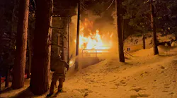
March 27, 2012

Articles

Photo by Joe Powers
fire department community risk reduction Charlottesville Virginia Fire Department
Joe Powers tells of how the Charlottesville, VA, Fire Department found the capability to improve its fire watch and frequent 9-1-1 caller reporting without spending a dime.
Sept. 19, 2024
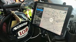
Photo courtesy of the San Bernardino County Fire Protection District
San Bernardino County, CA, Fire Protection District crews used operational intelligence that was powered by GIS to help to direct specialized resources and to navigate to emergencies during a major winter storm.
Jason Moore tells of how two fire departments use geographical information systems (GIS) to improve response and reduce community risk.
April 18, 2024
Photo courtesy of AIRT
Drones were used to map the Champlain Towers South incident scene for engineering evaluation of structural integrity, among several uses.
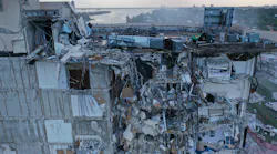
Charles Werner spoke to numerous people who responded to the condominium collapse to learn that unmanned aerial systems were crucial to the effort in many ways.
April 18, 2022

Request More Information From ESRI

By clicking above, I agree to Endeavor Business Media's Terms of Service and consent to receive promotional communications from Endeavor, its affiliates, and partners per its Privacy Notice. I also understand my personal information will be shared with the sponsor of this content, who may contact me about their offerings per their privacy policy. I can unsubscribe anytime.