Station Design: Accounting for a Changing Climate and Sea-Level Rise
When designing and constructing fire stations, police stations and other public safety facilities, the main focus is to support the specialized functions, workflow and systems that are required for emergency response. However, in a world in which environmental change is becoming a constant concern, those who conceive and supervise the construction of new fire facilities—along with the architects who design those buildings—must consider how to address ever-evolving climatic threats to the built environment.
Whether because of excessive rainfall, coastal tidal surge or the slow rise of water levels after storms, where rainwater storage needs exceed containment capacity, a thoughtful design approach is required in flood-prone areas. Exposure to high winds, wildfires, earthquake forces and pandemic threats also must be considered.
In addition to facility design, the site selection for these specialized building types must keep in mind appropriate location. That is based on the designated service area as well as how to stay connected to the local and regional transportation and utility grid to provide staffing and community connectivity and to ensure continuity of operations.
Planning process
The planning and design process for new or renovated facilities begins with a basic assessment of the vulnerabilities and opportunities that are contained in the project area and of the specific conditions of the site that’s being considered. A number of resources are available to establish these vulnerabilities and the conditions that your facility will need to endure. The list below provides an idea of the multiple considerations prior to design of the project.
Keep in mind that the information that follows continues to evolve, based on the updated experience of weather events. Maps are continually updated to provide a current picture of the state of the environment. As architects and engineers gather this information, they must extrapolate environmental conditions into the future by 30–75 years, which is the average range of the useful life of fire stations and police facilities.
Flooding. A flood-risk analysis for the site begins by determining whether the project is located within the 500-year flood plain. If that information isn’t available, use the 100-year flood plain and add two feet to that base flood measurement to obtain the design flood elevation. This is used to set the floor level of occupied space. This should be done for coastal projects and any projects that are located near inland bodies of water. (Consult the FEMA Flood Map Service Center. For areas for which limited flood information exists, use the FM Global Flood Map.)
Surge. Where applicable, create a Storm Surge Analysis, based on the worst-case hurricane event to be mitigated. (Consult the National Oceanic and Atmospheric Administration’s [NOAA] National Storm Surge Hazard Maps.)
Identify impacts that are associated with sea-level rise. Consider additional storm-surge impacts in connection with hurricanes and tropical storms. (Use the NOAA Sea, Lake and Overland Surges from Hurricanes [SLOSH] model data to interpolate storm surge. In the absence of SLOSH model data, use Surging Seas’ threat maps and forecasting tools.)
Sea-level rise and storm surge for 2022 and beyond should combine the high scenario for the year 2080 from NOAA’s 2012 “Global Sea Level Rise Scenarios for the United States National Climate Assessment” with a 1-in-100-year flood plain (extreme flood) to determine water levels for planning purposes.
Wetlands. Wetlands areas contain a high-water table (water that’s close to the surface of the natural grade) and hydric soils, which aren’t conducive to development and, in general, are prohibited by most development districts. Have a civil engineer or architect consult the U.S. Fish and Wildlife Service’s National Wetlands Inventory for information on surface waters and wetlands. Then review the local county GIS maps.
High-Wind Hazards. Hurricanes, tornados and other sudden-impact storm occurrences have been tracked and mapped for 100 years. This data, which are ever evolving, have been used to create maps of areas that are prone to high wind and to wind-borne debris. This information is used to understand the high-wind and wind-driven-debris impact that might affect the facility structure and building enclosure.
Use the ASCE 7 Hazard Tool as well as FEMA windspeed maps for hurricanes and tornados, which are found in the FEMA P-361 guidance document, “Design & Construction Guidance for Community Safe Rooms,” to determine the project location’s specific risk. Also refer to the adopted building code in the project area for windspeed maps, which, generally, are found in Chapter 16 of the building code, under structural provisions. The Risk Category 4 map should be used for all public safety projects that provide an emergency response to the public. The values that are indicated generally represent a higher windspeed and impact than for structures that are for general use.
Earthquakes. Seismic considerations can be confirmed by using the earthquake hazard maps as well as information that’s contained in the International Building Code (IBC). Hazards are measured as the likelihood of experiencing earthquake-shaking of various intensities.
Tsunamis. Tsunamis are created when earthquakes occur below the surface of bodies of water and can result in unexpected, dynamic flooding and surge of a shoreline area. Use the NOAA website to identify tsunami risk and to determine whether the project site might be within a tsunami-inundation zone 1. Mitigation strategies include relocating the project to higher ground that’s out of the tsunami risk area.
Wildfire. Determine whether the project is located in an area that’s designated a high or very high wildfire hazard potential. Also consider urban fires in densely populated urban residential areas that have older construction that lack interior sprinklers. Review the information that’s found in the U.S. Department of Agriculture and the U.S. Forest Service Wildfire Hazard Potential Map and on the Federal Fire Occurrence Map.
Once the environmental vulnerabilities are identified, strategies for mitigation and their costs can be identified. It will be important to create a pre-design planning document, which makes recommendations and options that are based on both best-practice design and code-minimum design. Each comes at a cost that’s based on local labor and materials costs. Balancing performance and cost should be done prior to creation of a final design and before construction commences.
Using a combination of IBC, state code requirements, and a variety of best-practice guidance publications and standards that are issued by FEMA and NFPA, the design team can provide a number of suggestions to incorporate into the design of the site and facility. Publications, such as “FEMA 543, Design Guide for Improving Critical Facility Safety from Flooding and High Winds: Providing Protection to People and Buildings,” are used to design site and facility solutions.Ideas for constructing facilities in flood-prone areas include:
- Raise the main living/occupied space above the flood and surge elevations
- Raise all utility connections for electrical and data primary and backup elements above the flood and surge elevations
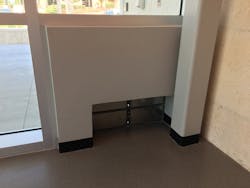
- Provide wet-flood-proofing where entry lobbies are subject to water intrusion or dry-flood-proofing if anticipated water intrusion is less than 3 feet high
- Build up the site by incorporating a wall or series of platforms and ramps to building entries
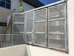
Creating a survivable structure includes designing walls, roofs, window and door openings, louver and other mechanical openings and elements to withstand high winds:
- Provide protection for all exterior components of electrical, mechanical, fuel and communications systems
- Provide adequate storage for deployable panels for windows, doors, etc.
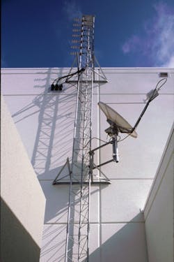
- Use retractable tower and antennae where possible to protect communications and weather stations from damage
Considerations for providing continuous electrical, data utility, water, sanitary and air-conditioning services include incorporating generators, fuel tanks, secondary HVAC units and pumps. Feeding the facility from at least two locations will provide the critical systems that are needed to continue to operate under disruptive operational conditions. These include on-site power generation, water and sanitary storage and the utilization of backup satellite communications systems.
Alleviating susceptibilities
Our world continues to experience sometimes volatile change, but we can respond with thoughtful site development and facility design. We must use the data that so many organizations have been collecting, which are based on real-world experience. The goal is to formulate design recommendations that can mitigate vulnerabilities, to create designs that allow first responders to meet the ongoing challenges that they face. That goal is achievable.
About the Author
Susan Gantt
Susan Gantt is a registered architect who specializes in the design of public safety facilities. She holds a Bachelor of Architecture degree from Virginia Polytechnic Institute and State University and a general contractor's license and is accredited as a LEED Accredited Professional by the U.S. Green Building Council. During her 38-year career, Gantt completed numerous projects, which included master planning, strategic planning & programming and design. She speaks at local seminars and national conferences as a practicing architect with Architects Design Group. Gantt has worked with the National Disaster Preparedness Training Center as a DHS Certified Instructor.


