Hot Spots Will Burn for Months After CA Wildfire
Source San Bernardino County Sun, Calif. (TNS)
SAN BERNARDINO -- Perched on the edge of San Bernardino Mountain communities, fire risk from the remnants of the Pilot fire will persist for months — well after its obvious signs have disappeared, fire officials said Thursday.
Recent infrared aerial photography reveals many pinpoints of extreme heat persisting in the center of what has already burned. Crews will be sent to those locations, but the reality is, hot spots in the Pilot fire area won’t be completely eliminated until after repeated rains this fall and into early next year, said Steve Seltzner, pre-suppression and fire planning chief for the San Bernardino National Forest.
Meanwhile, Thursday’s firefighting report said the Pilot fire is 70 percent contained, but still burning chaparral and brush between Pilot Rock Ridge and Highway 173 in Hesperia.
Helicopters are being used to help slow the fire progression until containment lines can be constructed in the areas north and northwest of Deer Park Lodge, the Thursday morning statement said.
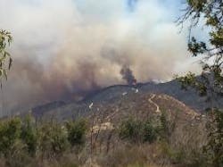
Midafternoon Thursday, thick billows of smoke from the San Bernardino Mountains were visible from the San Bernardino Valley below.
This was from a pocket of vegetation “well inside the containment line,” said Lyn Sieliet, a San Bernardino National Forest spokeswoman.
The community of Deer Park Lodge remains under mandatory evacuation, but voluntary evacuation advisories were lifted at noon Thursday for the city of Hesperia, town of Apple Valley and the community of Summit Valley, the incident command center said.
The fire’s starting point Sunday at Miller Canyon, at the eastern edge of Lake Silverwood, had “no history of fire,” Seltzner said.
The resulting chaparral and brush were 15 feet deep in some places, he said.
The combination of brush accumulation and extremely difficult terrain made this area “one of the worst places to have a fire,” Seltzner said.
The fire quickly advanced from Miller Canyon to Pilot Rock Ridge and moved into the Grass Valley drainage area, which would lead the fire to the many houses of Deer Lodge Park and along the north shore of Lake Arrowhead, Seltzner said.
On the ridge line, eight modern aerial tankers, including two McDonnell Douglas DC-10s, hammered the fire, said Chon Bribiescas, a U.S. Forest Service spokesman.
There were places where the fire burned through the aerial retardants. So an additional layer was applied, Seltzner said.
Although this happens with some fires, Seltzner said he believes this burn-through happened more with the Pilot fire because of the extreme drought.
The tankers are gone, but 12 helicopters remain to work with ground crews, according to Thursday’s report on the fire.
Winds cooperated with the firefighting effort by blowing from the south or southwest, pushing the fire to the Pinnacles, a group of small peaks away from where people live. There was brush accumulation in this area too, he said.
“If it had been a north wind, or worse a northwest wind, it would have been horrible,” Seltzner noted, as the fire would have likely quickly entered mountain housing areas. Fire crews would not have had time to build defensive lines to protect those mountain communities, he said.
“I hope they can button this up before we see any winds from the north,” he said.
“We will be out there (in the Pilot fire burn area) until the late fall or early winter,” Seltzner said. “This is going to be a long-term thing.”
The public can be helpful, acting as another set of eyes to tell fire officials if they see signs of fresh fire, he said.
Residents of Deer Park Lodge remember the horrific speed with which the October 2007 Grass Valley Fire spread from the San Bernardino National Forest to houses.
“Those 60 mph winds took the fire from the forest to our neighborhood in about 10 minutes,” Allan Rodgers, a longtime resident, said Tuesday.
Houses across the street from Rodgers’ were among the 199 homes destroyed or damaged by the fire.
So far, none of the more than 5,000 houses threatened by the Pilot fire have been destroyed or damaged, San Bernardino National Forest officials say.
———
©2016 the San Bernardino County Sun (San Bernardino, Calif.)
Visit the San Bernardino County Sun (San Bernardino, Calif.) at www.sbsun.com
Distributed by Tribune Content Agency, LLC.


